Hydrographic Services

Prudent’s Hydrography Department is equipped with advanced underwater surveying technologies that provide hydrographic survey and mapping services. With an experienced staff and cutting edge, sophisticated hydrographic tools, we provide accurate surveys of underwater environments.
Prudent’s hydrographic services are delivered in accordance with Corps of Engineers and International Hydrology Organization (IHO) standards. Our survey vessels are outfitted with advanced hydrographic software, allowing our staff to collect accurate data in a variety of underwater environments. With an experienced team and sophisticated equipment, we can effectively manage hydrographic survey/mapping projects of varying size and complexity.
Hydrographic Technology Employed
EdgeTech SB-216
Utilizing an EdgeTech SB-216, Prudent can gather detailed sub-bottom survey data for a range of engineering operations. The SB-216 can be deployed at depths up to 300 meters to document information on sub-bottom sediment and stratigraphy.
Applanix POS MV WaveMaster II
POS MV WaveMaster is a user-friendly, turnkey system designed and built to provide accurate attitude, heading, heave, position, and velocity data of your marine vessel and onboard sensors. POS MV is proven in all conditions, and is the georeferencing and motion compensation solution of choice for the hydrographic professional.
Applanix POS MV Surfmaster
Applanix offers a complete portfolio of products and solutions to support hydrographic surveying, including the POS MV SurfMaster for shallow waters.
R2Sonic 2024
With a need to support underwater inspection teams, Prudent purchased the R2Sonic 2024. The R2Sonic is mounted with a 30 degree articulating mount to allow it to capture data up to just below the water surface.
Seafloor Hydrolite Sonarmite
The Seafloor Hydrolite Sonarmite is a single-beam sonar system designed for shallow-water hydrographic surveys.
Knudsen Dual Frequency Single-Beam Sonar
The Knudsen is a single-beam sonar system for recoding changes in the seafloor over time. It specializes in doing port surveys and sedimentation surveys.
Seafloor HyDrone-RCV Survey System
Our Seafloor HyDrone-RC™ system is a portable surveying tool designed to conduct remote-control bathymetric surveys on ponds, lakes, rivers, and streams. The Seafloor HyDrone-RCV can be used to collect data in otherwise hazardous, inaccessible environments, such as sewage treatment facilities and contaminated waterbodies.
The Fleet
Prudent Engineering utilizes survey craft of varying sizes that measure from 10 to 33 feet. The largest of Prudent’s fleet, "Cat Tales" is a 33' aluminum catamaran purchased in 2018, “The Rough Draft” acquired in 2015, is a 2009 custom-built aluminum survey boat. Due to Hydrographic Survey demand, we found ourselves in need of yet another boat, and Prudent purchased a 22’ Lobell aluminum boat out of Mississippi, so we named her the “Misses Zippy”. She is equipped with push knees for pushing small barges, has a powerful 225 HP Honda outboard and is trailerable anywhere in the Northeast. The team is also equipped with a 6' remote controlled survey Zboat, which is able to get into the smallest bodies of water.
Services Under Hydrographic Services
- Single and Multi-beam Survey
- Side-scan Sonar Imaging
- Sediment Sampling
- Sub-bottom Profiling
- Bottom Classification Mapping
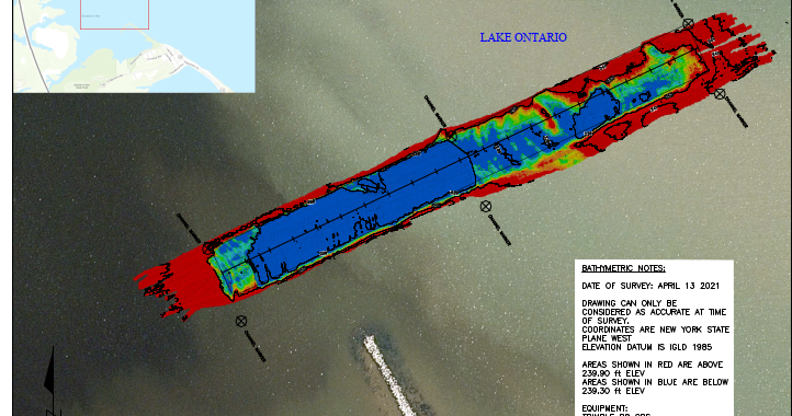
- Bathymetric Mapping
- Dredge Surveys
- Underwater Structural Imaging
- Hydraulic Cross Sections
Contact:
Philip Thayaparan, P.E., Principal-in-Charge, Manager of Hydrographic Services
pthayaparan@prudenteng.com
Explore Similar Projects
We are proud of each and every project. We are especially delighted to highlight a few projects to show the diversity of our work.


